


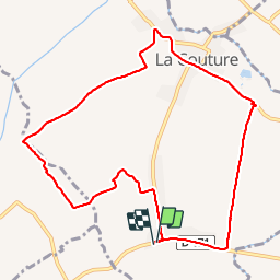
Les chouettes La Couture

Blourouce
User

Length
9.3 km

Max alt
23 m

Uphill gradient
24 m
Km-Effort
9.6 km

Min alt
16 m

Downhill gradient
24 m
Boucle
Yes
Creation date :
2019-01-12 16:54:40.202
Updated on :
2019-01-12 16:54:40.216
2h00
Difficulty : Very easy

FREE GPS app for hiking
 SityTrail
IGN / Geographical institutes
SityTrail Plus
The world is yours!
About
Trail Walking of 9.3 km to be discovered at Hauts-de-France, Pas-de-Calais, La Couture. This trail is proposed by Blourouce.
Description
Balade sympa dans la Campagne de La Couture 62136
Positioning
Country:
France
Region :
Hauts-de-France
Department/Province :
Pas-de-Calais
Municipality :
La Couture
Location:
Unknown
Start:(Dec)
Start:(UTM)
479226 ; 5601150 (31U) N.
Comments